
Blog
Trip Report Iceland
Iceland Trip Report
There has been quite a lot of interest in our trip from people thinking of visiting Iceland to hike and take photos. In this article I will try and outline what it was like for me to try and produce images while hiking unsupported for 5 or 6 days.
Firstly do not let any media hype of erupting volcanoes put you off. Yes they do play a big part in shaping the country but the risk of being on or near one when it erupts is miniscule. You are much more likely to come to harm on the way to the airport in the car than face any direct danger from an eruption. That said the usual risks associated with the outdoors applies here just as anywhere else in the world and you need to be well prepared, equipped and experienced in mountain travel.
About the Trek
The Laugavegurinn hiking trail (also known as the Laugavegur trail) is approximately 55km long and is Iceland's most popular hiking trail, connecting the nature reserves of Landmannalaugar and Thorsmork. We extended this walk by adding an extra 25-30km to visit the initial eruption site of the Eyjafjallajokull volcano which took place in the Fimmvorouhals Pass. We then continued down the other side towards the coast to the village of Skogar.
Landmannalaugar
We had arrived at Landmannalaugar the previous afternoon after a visually stunning bus ride from Reykjavik. The last few hours of which were on dirt roads only just wide enough for the 4X4 bus which bumped and clattered its way through the mountains, lava flows and scattered boulders. On the way, and in the middle of a black desert, we stopped to pick up a couple of cyclists as well as a pair of backpackers who were clearly knackered so simply waved us down. In the UK there is no way you could flag down a service bus and then pile all your bikes and baggage on and then head off. Here in Iceland though the bus driver simply stopped the bus chucked the bikes and kit on and off we bumped, no hassle, no drama - I loved this country already.
On arriving in Landmannalaugar we set the tents up and had a brew before heading off for a swim in the hot springs. Laying around in the hot water was lovely but getting out into a bitter wind was not so much fun. Later ominous black clouds began to build above the surrounding rhyolite mountains and it was time to get the camera out and capture some images. When the rain came, most people headed for the shelter of vehicles or tents, but we kept on shooting as a double rainbow appeared arcing across the landscape. Seconds later shafts of light began to illuminate the Barmur Rhyolite Mountains to the east. These appeared to glow from within as a slanting curtain of rain doused the mountains on the far horizon. Whatever else happened on this trip this moment would certainly remain etched on my mind.
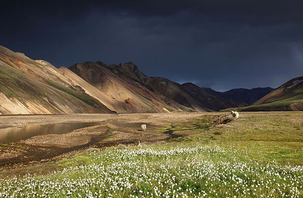
Ominous black clouds began to build over the Barmur Rhyolite Mountains. Image Copyright David Forster
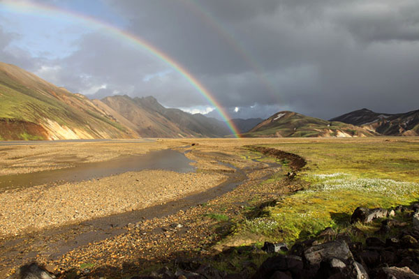
A double rainbow begins to form over the Barmur Rhyolite Mountains. Image Copyright David Forster

The rainbow eventually stretched across the horizon framing the mountains. Image Copyright David Forster
The Start of the Trek.
We were up at 7.00am and away for 9.30am after a very leisurely start in which we enjoyed a couple of brews and waited for the cloud to lift a bit. The aim today was to reach the mountain hut of Hoskuldsskali where it is possible to camp. It's only a distance of 12km or so, but it involves a 1500ft ascent as well as the crossing of a very exposed upland area at around 3,000ft. The weather then, would make or break our day.
Landmannalaugar - Hrafntinnusker Elevation Increase Approx 470m
As we left Landmannalaugar the mountains were still cloaked in cloud so we simply enjoyed the closer views of the Laugahraun lava field where large boulders of Obsidian lava had split to reveal the black glassy cores. With these black heat-contorted rocks it was easy to visualise the noise, heat and smoke as it steadily engulfed the underlying landscape. We were almost across the lava field when the cloud lifted to reveal steam rising from vents on the lower slopes of the Brennisteinsalda volcano. Now in the sun the surrounding rhyolite mountains appeared to smoulder anew. The mineral stained rocks of intense red, yellow, green and blue contrasted sharply with the more pastel shades of greys and browns to form a shimmering backdrop. Approaching the vents the smell of sulphur was very intense and we did not linger in the steam too long. Others though walked into the steam and gas so we photographed their shimmering silhouettes as they appeared and disappeared in the heat.

Clouds of steam and sulphur gas envelop walkers as they explore. Image Copyright David Forster
Eventually we reached the high and exposed upland where snowfields still linger waiting for winter. Lower down we had enjoyed the warm sunshine, up here though the wind had a definite edge to it and we were forced to put on an extra layer. In fact the whole landscape had an edgy feel to it as cloud threatened to descend and cut off visibility. Fortunately as we slowly made our way across ash-blackened snowfields towards the high point it only remained a threat. Nearing the col we came across a cairn with the name of Ido Keinan a 25year old walker who had died here on 27th June 2004 during a blizzard. We knew the hut was only a few km away and seeing this memorial certainly reinforced how dangerous any mountain area can be when the weather turns. Less than an hour later we were at the hut searching out a sheltered spot among the boulders, stones and black volcanic dust that would be our campsite for the night. There is no vegetation here to speak of and it does feel pretty bleak and exposed - it does however boast a "long drop" toilet. Nearby fumaroles produced columns of steam while the all-pervading smell of rotten eggs indicated sulphur gas continually crept across the land.
Day 2 Hrafntinnusker - Alftavatn 12 km Elevation Decrease 490m
We were up at 06.30am to low cloud and drizzle and in the hope it would clear we again had a leisurely breakfast. Leaving camp at 08.30am the trail took us through an area of snow filled ravines some of which had steam vents issuing from them. One ravine in particular highlighted the risks of walking on such terrain. Here the underlying snow had melted leaving several holes and snow bridges. Taking no chances we crossed carefully one at a time. A few yards further and our one at a time caution was justified. Here a large hole had opened up where a snow cave had formed and then subsequently collapsed. While not having the depth of a glacial crevasse a fall through a roof into one of these would certainly cause serious injury.

These snow filled ravines contained holes and crevasses that were not always easy to spot. Crossing them in the early morning while the snow was still frozen was the safest option. Image Copyright David Forster

Graham checking out the collapsed ice cave. Needless to say we did not go inside. Image Copyright David Forster
A steep pull eventually led to the high point of the day. By now the cloud had lifted providing a good view of this morning route from the hut. This was also the point where we would leave the Rhyolite Mountains behind and make our way towards the darker palogonite mountains to the South.

The view back over this mornings route towards the Hoskuldssklai Hut which sits just below the far horizon. Image Copyright David Forster
Beyond on the far horizon we had our first view of the glaciers we would need to find a way through in order to reach Skogar 3 or 4 days away. Below we could clearly see the green valley containing Lake Alftavatn and our campsite for the night. Importantly after the bleakness of the last campsite it had the look of an oasis.
There has been quite a lot of interest in our trip from people thinking of visiting Iceland to hike and take photos. In this article I will try and outline what it was like for me to try and produce images while hiking unsupported for 5 or 6 days.
Firstly do not let any media hype of erupting volcanoes put you off. Yes they do play a big part in shaping the country but the risk of being on or near one when it erupts is miniscule. You are much more likely to come to harm on the way to the airport in the car than face any direct danger from an eruption. That said the usual risks associated with the outdoors applies here just as anywhere else in the world and you need to be well prepared, equipped and experienced in mountain travel.
About the Trek
The Laugavegurinn hiking trail (also known as the Laugavegur trail) is approximately 55km long and is Iceland's most popular hiking trail, connecting the nature reserves of Landmannalaugar and Thorsmork. We extended this walk by adding an extra 25-30km to visit the initial eruption site of the Eyjafjallajokull volcano which took place in the Fimmvorouhals Pass. We then continued down the other side towards the coast to the village of Skogar.
Landmannalaugar
We had arrived at Landmannalaugar the previous afternoon after a visually stunning bus ride from Reykjavik. The last few hours of which were on dirt roads only just wide enough for the 4X4 bus which bumped and clattered its way through the mountains, lava flows and scattered boulders. On the way, and in the middle of a black desert, we stopped to pick up a couple of cyclists as well as a pair of backpackers who were clearly knackered so simply waved us down. In the UK there is no way you could flag down a service bus and then pile all your bikes and baggage on and then head off. Here in Iceland though the bus driver simply stopped the bus chucked the bikes and kit on and off we bumped, no hassle, no drama - I loved this country already.
On arriving in Landmannalaugar we set the tents up and had a brew before heading off for a swim in the hot springs. Laying around in the hot water was lovely but getting out into a bitter wind was not so much fun. Later ominous black clouds began to build above the surrounding rhyolite mountains and it was time to get the camera out and capture some images. When the rain came, most people headed for the shelter of vehicles or tents, but we kept on shooting as a double rainbow appeared arcing across the landscape. Seconds later shafts of light began to illuminate the Barmur Rhyolite Mountains to the east. These appeared to glow from within as a slanting curtain of rain doused the mountains on the far horizon. Whatever else happened on this trip this moment would certainly remain etched on my mind.
Ominous black clouds began to build over the Barmur Rhyolite Mountains. Image Copyright David Forster
A double rainbow begins to form over the Barmur Rhyolite Mountains. Image Copyright David Forster
The rainbow eventually stretched across the horizon framing the mountains. Image Copyright David Forster
The Start of the Trek.
We were up at 7.00am and away for 9.30am after a very leisurely start in which we enjoyed a couple of brews and waited for the cloud to lift a bit. The aim today was to reach the mountain hut of Hoskuldsskali where it is possible to camp. It's only a distance of 12km or so, but it involves a 1500ft ascent as well as the crossing of a very exposed upland area at around 3,000ft. The weather then, would make or break our day.
Landmannalaugar - Hrafntinnusker Elevation Increase Approx 470m
As we left Landmannalaugar the mountains were still cloaked in cloud so we simply enjoyed the closer views of the Laugahraun lava field where large boulders of Obsidian lava had split to reveal the black glassy cores. With these black heat-contorted rocks it was easy to visualise the noise, heat and smoke as it steadily engulfed the underlying landscape. We were almost across the lava field when the cloud lifted to reveal steam rising from vents on the lower slopes of the Brennisteinsalda volcano. Now in the sun the surrounding rhyolite mountains appeared to smoulder anew. The mineral stained rocks of intense red, yellow, green and blue contrasted sharply with the more pastel shades of greys and browns to form a shimmering backdrop. Approaching the vents the smell of sulphur was very intense and we did not linger in the steam too long. Others though walked into the steam and gas so we photographed their shimmering silhouettes as they appeared and disappeared in the heat.
Clouds of steam and sulphur gas envelop walkers as they explore. Image Copyright David Forster
Eventually we reached the high and exposed upland where snowfields still linger waiting for winter. Lower down we had enjoyed the warm sunshine, up here though the wind had a definite edge to it and we were forced to put on an extra layer. In fact the whole landscape had an edgy feel to it as cloud threatened to descend and cut off visibility. Fortunately as we slowly made our way across ash-blackened snowfields towards the high point it only remained a threat. Nearing the col we came across a cairn with the name of Ido Keinan a 25year old walker who had died here on 27th June 2004 during a blizzard. We knew the hut was only a few km away and seeing this memorial certainly reinforced how dangerous any mountain area can be when the weather turns. Less than an hour later we were at the hut searching out a sheltered spot among the boulders, stones and black volcanic dust that would be our campsite for the night. There is no vegetation here to speak of and it does feel pretty bleak and exposed - it does however boast a "long drop" toilet. Nearby fumaroles produced columns of steam while the all-pervading smell of rotten eggs indicated sulphur gas continually crept across the land.
Day 2 Hrafntinnusker - Alftavatn 12 km Elevation Decrease 490m
We were up at 06.30am to low cloud and drizzle and in the hope it would clear we again had a leisurely breakfast. Leaving camp at 08.30am the trail took us through an area of snow filled ravines some of which had steam vents issuing from them. One ravine in particular highlighted the risks of walking on such terrain. Here the underlying snow had melted leaving several holes and snow bridges. Taking no chances we crossed carefully one at a time. A few yards further and our one at a time caution was justified. Here a large hole had opened up where a snow cave had formed and then subsequently collapsed. While not having the depth of a glacial crevasse a fall through a roof into one of these would certainly cause serious injury.
These snow filled ravines contained holes and crevasses that were not always easy to spot. Crossing them in the early morning while the snow was still frozen was the safest option. Image Copyright David Forster
Graham checking out the collapsed ice cave. Needless to say we did not go inside. Image Copyright David Forster
A steep pull eventually led to the high point of the day. By now the cloud had lifted providing a good view of this morning route from the hut. This was also the point where we would leave the Rhyolite Mountains behind and make our way towards the darker palogonite mountains to the South.
The view back over this mornings route towards the Hoskuldssklai Hut which sits just below the far horizon. Image Copyright David Forster
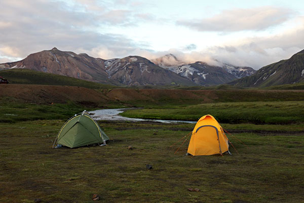
Beyond on the far horizon we had our first view of the glaciers we would need to find a way through in order to reach Skogar 3 or 4 days away. Below we could clearly see the green valley containing Lake Alftavatn and our campsite for the night. Importantly after the bleakness of the last campsite it had the look of an oasis.
11.30pm This campsite was like an oasis compared to last nights. Image Copyright David Forster
Day 3 Alftavatn - Emstrur (Botnar) 16km Elevation Decrease 40m
I awoke in the early hours to the sound of wind sweeping across the hillside and shaking the tent. It would then go completely silent and I would doze off, only to be awoken again as the next blast came down off the mountain. Every now and again the wind would also bring rain, which rattled against the tent. Not a very good omen for the start of day 3. We were up at 6.00am but the strength of the wind meant we were forced to make a brew and eat our breakfast inside the tent. This is a slow process as moving around with a lighted gas stove in the porch is not safe, so things like dressing and packing away sleeping bags have to wait. Anyway laying back having a brew in the warmth of your sleeping bag is always a luxury on trips like this. It was also noticeably colder so it was a good excuse anyway.
Within minutes of leaving camp just after 8.00 we came across our first obstacle of the day, a small stream. Fortunately we were able to find a way across without resorting to wading. Unfortunately we were not so lucky 15 minutes later when we were faced with the River Bratthalskvisl. It was off with the boots and socks, up with the trousers and on with my new £6.99 plastic shoes, bought especially for the job of crossing rivers. The river was fairly shallow but very cold and we were all left gasping when we reached the other side. Graham provided a bit of light entertainment by wearing a plastic bag on one foot to prevent the strapping on his heel from getting wet. It worked fine and he seemed quite chuffed.
By the time we reached the nearby small mountain hut of Hvanngil the wind was still coming in strong gusts but did not really bother us. A little further on we were able to cross the River Kaldaklofskvisl on a substantial bridge only to be met a few minutes later with another river, this time without a bridge. This was substantially more powerful and a lot wider than the last but we all waded across without too much trouble. Well all except Graham who's plastic foot bag leaked - snigger.

Hikers Crossing a Bridge Over the River Kaldaklofskvisl with the Mountain of Storasula Behind. Image Copyright David Forster
Ahead we had the flat desolate volcanic area of Emstrur to cross and initially this went easily enough. Ahead we could see a heavy mist sweeping across our path and partially blocking out the mountains ahead. At first we assumed it was low cloud sweeping down from the glaciers and it was only as we got closer that we realised it was volcanic dust being driven along by the strong wind. I took a few quick if distant pictures before stowing the 5D away in a dry bag. There was no way I was going to risk damaging the best part of £3,000 worth of camera. Instead Moira passed me the G10 so that I could get a few stills and some video. Big mistake, within a couple of minutes and despite protecting the camera from the worst of the dust it soon started to malfunction. Eventually the shutter would not fire and the video would only record monochrome, I was certainly glad I put the 5D away. This was disappointing, as words cannot describe adequately just how bad these dust storms were. At times it was not possible to see more than a few meters and at one stage we nearly missed a marker pole that would take us onto the correct track. With hoods up and buffs protecting our mouths we trudged on. Every now and again the wind dropped the sun blazed down and we had extensive views to the glaciers of Myrdalsjorkull (which overlays the massive Volcano Katla) and of course Eyjafjallajokull under which the volcano that produced this ash still simmered. Minutes later the maelstrom would return and we would retreat into our hoods like tortoises.
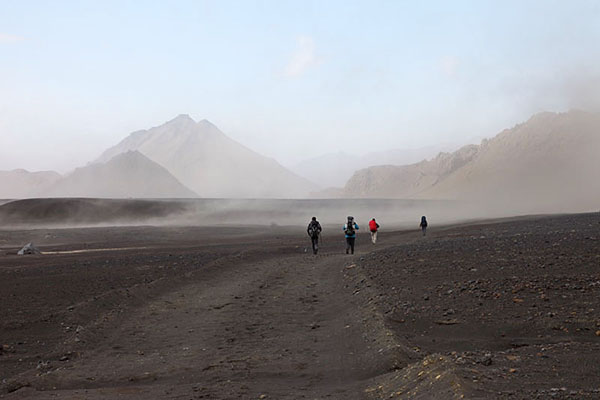
From a distance we initially thought this was mist decending from the glaciers. Image Copyright David Forster

Getting closer we realised it was volcanic ash still moving around the landscape. Image Copyright David Forster
Much later we discovered that Sandra had fallen foul of the dust squalls when she realised she had lost her camera at our rest stop five or six kilometres back. Unfortunately there was no way we could manage an additional 10km round trip to go back into the dust to look for it as we were all pretty tired by now, so instead we simply plodded on. Eventually when the worst seemed over I chanced using the 5D again to capture some of the drama behind.

This image still cannot truly convey how bad it was to be engulfed in the dust. Image Copyright David Forster

Graham with dust storms behind. Image Copyright David Forster
Then rounding a corner we saw the hut. So all in all it was an exiting if slightly challenging day and we could get the tent set up and relax over a brew. Err well no the wind and volcanic dust had far from finished with us. At the camping area below the hut we managed to find three unoccupied spaces on a ledge in a small valley. Two were on flat volcanic dust covered ground while a third was on lumpy sloping grass. We chose the flat ground only to find that when the wind changed direction it blew extremely fine dust through the tents side vents and eventually even through the fabric of the inner. Within minutes our sleeping bags, tent and clothes were coated in an ever increasing layer of dust with the consistency of gritty talcum powder. The only way to improve our situation was to take the tents down and move them onto a steep and bumpy grassy slope below. Hopefully most of the dust would blow over the top of the tent rather than under and inside. Even so once set up it was only a marginal improvement as it then started raining, turning the dust to sludge instead. Still it could have been worse. A day later at Thorsmork we got chatting to a schools expedition from Bath who were camped in the dusty bowl below us. They had experienced an even worse time with the dust. One teacher in a more exposed tent awoke in the early hours covered in so much dust she simply sat with her waterproofs on until everyone got up. The kids though loved it and despite the hardships had had a great time and were justly proud they had completed their challenge.
Day 4 Emstrur (Botnar) - Thorsmork 15km
The rain driven by a strong wind had been hammering against the tent intermittently for the past couple of hours. It was now 6.00am and I had slid down the slope into the bottom of the tent yet again. It was pointless laying here wide-awake until the others woke so I sat up to put a brew on. Reaching for the stove I could see a thin film of dust on my dry-bag and when I moved my jaw I could feel the dust crunching between my teeth. Even my ears and hair were full of dust and as I looked over to Moira who was in the same state we started laughing - it sounds strange but we were still having fun. It seemed to take ages to get coffee and breakfast sorted out but the delay meant that by the time we emerged from the tent it had stopped raining. We were on the trail by 08.30 but before leaving the area we stopped to read the warning sign at the top of the hill. "When it has been confirmed that Katla is erupting maroon flares will be fired". The warning went on to advise which routes to use in order to escape the mountains. I photographed the warning sign for later reference just in case.
The wind today was much more powerful than yesterday although the heavy showers meant there was much less dust in the air. After 45 minutes or so the first obstacle appeared - the descent and crossing of the canyon of Syori-Emstrua. Moving down towards the narrow bridge that spanned the canyon a rope was already in place to help on the last few metres of the descent. Safely down we could now get a good look at the narrow bridge high above the raging torrent. It looked fine but unfortunately the wind was now being funnelled between the canyon walls. It was certainly a little un-nerving as it blasted past grabbing at our rucksacks and threatening to unbalance us. In these situations it's often best to get on with it, so we did and were all safely over quite quickly. An easy walk/scramble soon saw us out of the canyon where the walking was easy and the trail straightforward to follow.

The bridge across the canyon of Syori-Emstrua. Here the strong wind was being funnelled through the canyon which made for quite an exciting crossing.
From now on the vegetation increased considerably with lots of Dwarf Willow, Lupin, Sweet Peas, Thrift, Bladder and Moss Campion as well as numerous other flowers appearing. Several hours later we eventually arrived at the River Pronga, the deepest and most dangerous of the rivers so far. To cross we needed to strip down to our underwear in order to prevent our trousers from getting soaked, so just in case we were not enjoying ourselves enough it also decided to start pouring with rain - typical. While getting sorted we watched two other groups cross over and it looked a little hairy at times. One guy only rolled up his trousers and paid the price with a good soaking up to the top of his thighs. Next went a young woman who was rather petite and was clearly struggling to stay upright as the current tried to drag her legs from under her. Her friends though were quickly on hand and stepped back into the river themselves to provide assistance. Next it was our turn so we verbally went through the drill we would use should one of us be swept off our feet, made sure our rucksack straps were loose, poles lengthened and off we went. While only just above the knee the current was very strong and the boulders in the bottom meant it was awkward to keep your balance. With all four of us safely across we got dried as best we could and made our way through birch woodland to arrive in Throsmork just as the rain stopped.

Graham and Sandra crossing the River Pronga in the rain. Image Copyright David Forster
Below is a short video of another couple making their way across
Hikers Crossing the River Pronga in Iceland Credits Filmed by Graham Brown, Edited by David Forster on Vimeo.
Day 5 - Thorsmork - Basar Campsite 5kmOfficially we had now completed the Laugavegurinn hiking trail, however we also wanted to visit the site of the initial Eyjafjallajokull eruption and then continue on to Skogar. To do this we had several choices, we could climb to the very exposed Fimmvorouhals Pass where the eruption took place and stop overnight, or we could do the whole walk of 25km and an ascent of 2,000 feet or so in a single day. This could certainly be done with the current food supplies, however we felt it would be a good idea to have a rest day. Asking around to find out where we could find a shop to obtain some extra supplies the School expedition from Bath we had seen earlier generously offered us some of their spare food. They had achieved their goal and did not need it as they were heading back to Reykjavik the next day. Thanks everyone.
Being a rest day we had a short walk of 5km to the Basar campsite from where we would begin our ascent the next day.
Day 6 Basar Campsite to Skogar 25 Km
When we set off we had still not fully decided if we would spend the night at one of the two mountain huts on the Fimmvorouhals pass, or continue straight over to Skogar. The weather it has to be said was not looking all that promising so we decided to make a decision when we got to the hut. That way we could either stay at the hut, push on to Skogar, or retreat as conditions dictated. We did speak to the campsite warden about conditions and being aware of what we had already achieved his advice was simply to turn back if you have any problems. Weather wise though it was not an easy call - it never is in Iceland. At two of the huts we had passed earlier in the week I had looked at the weather reports. All they said was "RAIN or SUNSHINE - accuracy 50%". To be fair that had been our experience as well.
Starting from Basar we would walk through the area known as Gooaland, the Land of the Gods. Making our way steadily up the Kattarhryggir ridges I could certainly appreciate how the name came to be. Surely in these green steep sided mountains covered here and there with trees and wild flowers, there could be elves and other mythical creatures. They must be there, at least in a spiritual sense anyway. Gaining height we eventually left the lushness below and stepped onto the desolate rocky plateau of Morinsheioi. Immediately the mood changed, the wind was much stronger here forcing us to put on extra layers. To the left the volcano Katla slumbered quietly under its glacial blanket of snow and ice, while to the right the Eyjafjallajokull volcano rested after its recent labours.

Graham and Sandra on the Kattarhryggir Ridge looking towards the Katla Volcano which is covered by Myrdalsjokull Glacier. Image Copyright David Forster
Crossing the plateau we came to the point where lava from Eyjafjallajokull had poured over the cliffs creating an extremely rare lava fall into a deep valley that barred our way. Steam was still spiralling out of the larger flow to our left. Ahead the way was clear, first we needed to descend a short way to a mini col before making an upward traverse through a broken crag above a very steep slope. This path was protected by a wire rope and would give access a small snowfield above. As we looked up a small group began descending so we took the opportunity to have a quick break while they cleared the steep ground.
The first down stopped to talk. " How's it going, are you going over the top to Skogar"?
"Yes"
"If you are it may be best to stay at the hut tonight as there is a big storm coming in behind us, 70 mile an hour winds and heavy rain are expected. "You will feel the wind once you are over the top here" he said pointing at the hill above. Adding "Once on top it will take you an hour to reach the hut"
This was bad news but we had planned for this eventuality anyway - we would still decide what to do once we reached the hut. It was a bit of a slog up to the pass and it was as he had warned very windy. Bad weather clouds were arching over the mountains to the north and the sky had an ominous look about it. Our exploration of the volcano would need to be quick. Fortunately marker poles had been placed across the lava flow and we carefully made our way over to meet Magni and Modi Iceland's newest hills and craters. Each was formed during the initial Eyjafjallajokull eruption and have been named after the sons of Thor the mythical Norse god of thunder.

Magni and Modi Iceland's newest hills and craters formed during the initial Eyjafjallajokull eruption. Image Copyright David Forster
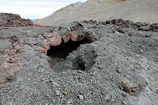
Collapsed lava tube. You needed to be careful walking over the cooling lava flow as there were lots of holes and hollows. Fortunately yellow poles mark the trail. Image Copyright David Forster
The marked trail actually passed inside the eruption craters and in places steam and gas swirled from the still cooling lava. Photography wise there was little opportunity for creative shots as the light was extremely flat so we had to make do with some simple record shots and some short video clips. We would have liked to have spent much longer here exploring, however we still had a fair way to go to the hut and the wind was increasing by the minute so we pushed on.
There are two huts at the Fimmvorouhals Pass. The first Fimmvorouskali is manned and sits on a ridge just off the trail. The other Baldvinsskali is not manned and is in a pretty rundown grubby condition. The original plan was to stay at the manned hut if the weather was bad or we felt we needed to rest so now that we were here we needed to make a decision. Push on or stay. Clear views under the cloud down to the coast suggested that the weather while clearly turning stormy was not going to arrive for perhaps 3 or 4 hours. In that time we would be off the high ground and well on the way to Skogar. We all felt fit so the decision was made to take a quick break at the unmanned Baldvinsskali hut and then push on for Skogar.
At the hut we met a young couple from Switzerland one of whom was injured and recovering from an epic couple of days. Sharing some of our hot water with them we quickly got some hot food into us while the young lad recounted their experience.
The lad had badly injured his knee yesterday while trying to cross the pass with two friends and could barely walk. Fortunately they had stumbled across the hut in the thick mist so the couple sensibly decided to spend the night there. The two so called friends took their map and stove and carried on over to Thorsmork, leaving them to try and return to Skogar on their own. Luckily for them a rough vehicle track leads across the nearby hillside and by chance a group had turned up with a large off road vehicle. The group had now left to visit the other hut on foot but would return in 3 or 4 hours to take them down.

The unmanned Baldvinsskali Hut is in a pretty rundown and grubby condition. That said it was ideal for us to get the stove on and have something to eat before the long decent to Skogar. Image Copyright David Forster
While eating we were constantly reminded of the urgency to get down, as every now and again the wind would drone past the windows causing the hut to creak and groan. That said it is a balancing act to progress safely in the mountains and you cannot move quickly in deteriorating weather when energy levels are low. What we placed in our reserve bank now calorie wise, would see us most of the way to Skogar.
In the end this proved a good decision and several hours later in heavy rain we eventually dropped down the side of the Skogafoss waterfall to the campsite. That was it, the end of our adventure. Next morning we photographed Skogafoss in the rain, had a meal in a restaurant, bought our bus tickets and were enjoying a whisky on the campsite is Reykjavik by 9.00pm. Unfortunately it continued to rain for the next few days so photography wise we did very little. All in all though it was a brilliant trip and I cannot wait to go back.
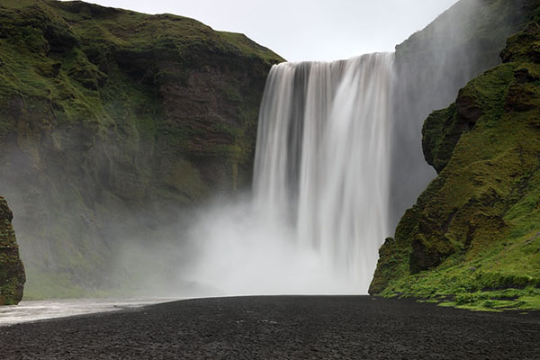
It rained all night but it did not spoil the spectacle of Skagafoss waterfall. Image Copyright David Forster

No chance of getting a shot of the rainbow that appears when the sun shines. Still a long exposure adds to the drama. Image Copyright David Forster
Further Information
The Country
Iceland is often referred to as the land of ice and fire and for good reason. It has several large glaciers and around 130 volcanoes, a small number of which have been active over the last few decades. Given that some of these volcanoes lie under glaciers when an eruption does occur it tends to be explosive and coupled with severe flooding. Two of these volcanoes have erupted during the last year or so. The Eyjafjallajokull volcano which erupted twice in 2010 and the Grimsvotn volcano which erupted on the 21st May 2011. Both caused air travel disruption by ejecting thousands of tons of ash into the atmosphere. The shorter Grimsvotn eruption alone produced 2000 tons of ash per second! I don't know how much ash was produced by the much longer Eyjafjallajokull eruption, but it certainly provided us with some challenging conditions for a couple of days.
The People
There are only three hundred thousand people in Iceland, the majority of which live in the capital Reykjavik. Friendly, laid back and good-humoured is an easy way to describe our dealings with the locals.
Equipment
While there are several mountain huts on the trail it is not possible to buy food so we had to carry enough food for 6 days (6 days walking + reserve food). We did hear from other trekkers that we could get some basic if expensive provisions once we got to Thorsmork, however we had no idea what these would be food wise so planned to be self sufficient. Considering we also needed to carry tents, sleeping bags, first aid, spare clothes, professional camera equipment and the usual kit you need for a day in the mountains we had to give a lot of thought to what would go in the rucksack.
Food
Food wise for main meals we purchased freeze-dried meals from Be-Well Expedition Foods. These proved excellent value for money, were easy to prepare by simply adding boiling water and were very tasty. From the range of meals available we all agreed that The Beef Shepherds Pie and Thai Chicken were our favourites. The Beef Stroganoff and Beef Curry were also pretty decent. For those who like vegetarian fare the Vegetarian Cottage Pie was excellent. Least liked was the Chilli Con Carne which for me was barely edible. I will try to do a balanced article specifically on these foods if anyone is interested. To cook we used Coleman gas cylinders available from either the City Campsite in Reykjavik as well as most gas stations (petrol stations).
Camera Kit
There is no getting away from it I want decent quality images that can be reproduced in magazines, books, newspapers etc and as such need to take an SLR camera. Yes they are heavier than a compact, but while most small compacts are great for general images they cannot match the quality of an SLR such as the Canon 5D - not at present anyway. The Canon G series of campacts are fairly good but only as a backup in desperation. Forget the argument I often hear that most 10 -14 million pixel compacts will match a SLR. They won't - sensor sizes are different and high pixel counts crammed onto small sensors do not produce quality images. So with weight issues in mind I decided to accept the risks of carrying only one SLR camera body instead of following my usual rule of having a second as backup. Instead I decided to compromise and Moira would carry a Canon G10 as backup and for personal use. Had this been a purely photographic or client funded trip then the risk of carrying only one camera would have been unacceptable.
Kit Carried on the Trek
Canon 5D Mk2 with 24-105 IS L series lens
Remote cable release
2 Spare batteries
4 Compact Flash cards 1x32GB 2x16GB and 1x8GB (enough for 2000 RAW images)
Graduated ND Filter
Polarising Filter
Mini tripod adapted to fit onto 3 trekking poles to form a tripod (it worked brilliantly)
Small Cleaning Kit
SLR camera bag
Camera Equipment Left in Storage at Reykjavik
1x Battery charger
1x Extender
Further Information
Part of our walk was also completed by Julia Bradbury for her BBC Walks Series. Its well worth watching if you are planning to complete this trek.
Text and Images Copyright David Forster 2011